Getting Your Height Right
A Creator's Guide to 3D Elevation
You've just captured a stunning 3D model of your favorite landmark. The details are crisp, the textures are perfect. You upload it to the Construkted Globe, eager to share your contribution with the world... but it's floating 50 feet in the air, or worse, buried halfway underground. What happened?
If this sounds familiar, you're not alone. The truth is, "elevation" isn't one single, simple measurement. The accuracy and beauty of any digital world---and our shared digital Earth---depend on understanding how height is measured.
This guide will demystify the key types of elevation. By the end, you'll not only understand why your models sometimes float, but you'll also have the knowledge to ensure your creations are perfectly placed, every single time.
The Foundation: Measuring from the Right "Zero"
Every vertical measurement needs a starting point, a "zero level" to measure from. In the world of 3D data and GIS, the two most important starting points are the Ellipsoid and the Geoid.
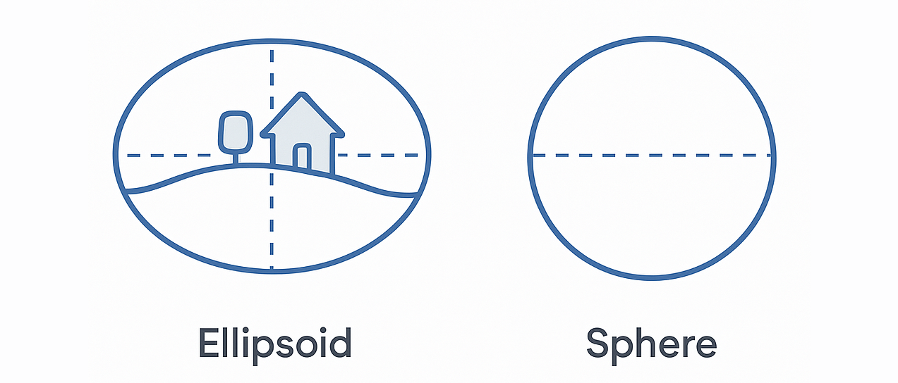
- The Ellipsoid (The Squished Sphere): Imagine a perfectly smooth, slightly squished shpere model of the Earth. This shape is also called the Ellipsoid. It's the native language of all GPS, GNSS, and satellite systems because its simplicity makes calculating positions fast and reliable.
- The Geoid (The "Real" Sea Level): Now, imagine a model that represents the Earth's true, lumpy gravitational surface---a model of where the oceans would settle if they were only affected by gravity. This is the Geoid. It's complex and irregular, just like our planet. Think of it as a lumpy potato that better represents Earth's actual shape.
This shapeis also called the Orthometric height.

The elevation variation across the surface of the planet.
Source: Wikipedia
The difference in height between these two models is often the source of those mysterious floating assets.
The Two Key Heights: What Your Data is Telling You
Because there are two foundational "zero points," there are two primary types of height measurement.
-
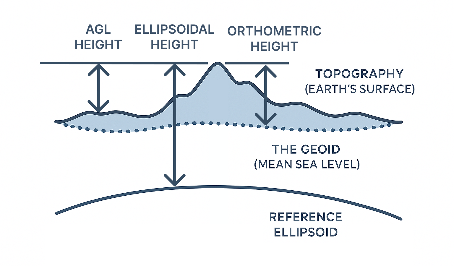
Ellipsoidal Height: This is the height measured from the Ellipsoid.
This is the raw height automatically captured by your drone, smartphone GPS, or satellite imagery. It's the global standard for positioning. -
Orthometric Height (Height Above Sea Level): This is the height measured from the Geoid.
This is the elevation you see on traditional topographic maps and use for real-world applications like city planning and construction. It's what most of us intuitively think of as "elevation." -
AGL Height (Above Grould Level): This is a relative measurement above the ground at a specific location on the surface.
Surface vs. Terrain: What Are You Actually Mapping?
The next critical piece of the puzzle is understanding what your model actually represents. Are you mapping the ground, or everything on top of it?
-
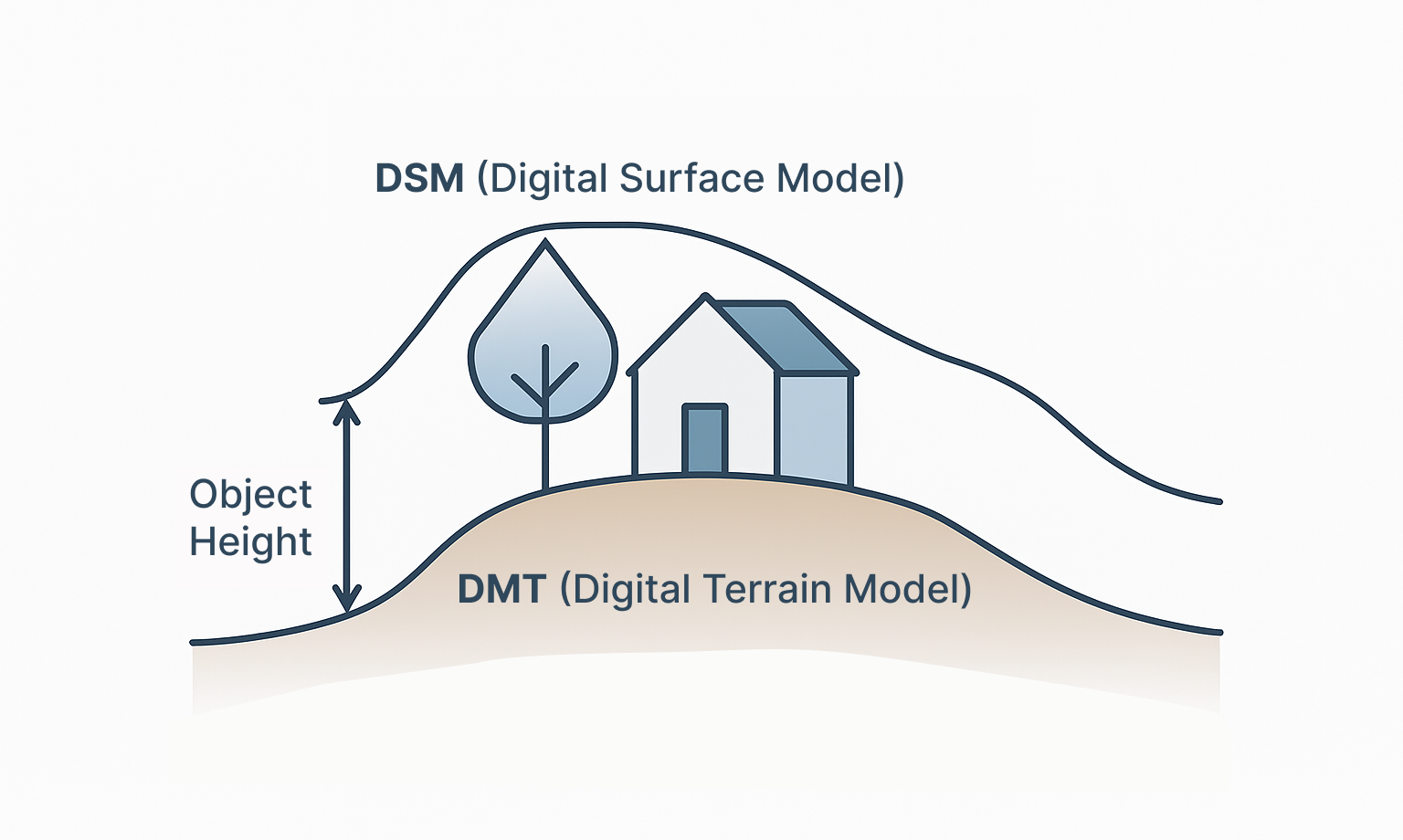
Digital Surface Model (DSM): The World As You See It
A DSM captures the elevation of everything on the surface---buildings, trees, cars, and infrastructure. This is the rich, detailed model you get from a raw photogrammetry scan. On Construkted Reality, DSMs are what create the visually stunning, explorable models of our cities and landscapes. -
Digital Terrain Model (DTM): The Bare Earth Beneath
A DTM, on the other hand, represents the elevation of the "bare earth" after all the buildings, trees, and other objects have been digitally removed. It's the planet's foundational landscape. The Construkted Globe is built on a global DTM, which is the secret to ensuring that all our users' contributions sit on the correct ground level.
Bringing It All Together on the Construkted Globe
Here's where the magic happens. You don't need to be a GIS expert to contribute to our digital Earth, because Construkted Reality is designed to handle this complexity for you.
The elevation used by Construkted Reality is always Ellipsoidal Height.
When you upload a WGS84 geo-referenced asset Asset, it is assumed that the elevation is correct.
If the model is NOT geo-referenced, you will have to provide the asset elevation.
Quick Tips for Perfect Uploads
- Know Your Source. Check your capture software (like Pix4D, DJI Terra, or RealityCapture) to see which vertical datum it uses and change it to Ellipsoidal Height.
- For Professionals: Use Ground Control Points (GCPs). For survey-grade accuracy, using GCPs with known real-world elevations is the best way to anchor your model perfectly.
- When in Doubt, Upload. Our system will tell you what needs to be updated in order to allow the model to be displayed correctly.
Conclusion: You are a Digital Cartographer
Understanding elevation transforms you from someone who simply makes 3D models into a true digital cartographer. Every accurately placed Asset is more than just data; it's a permanent, valuable contribution to our shared mission: building a global community united by a user-generated digital Earth.
Ready to make your mark? Grab your best 3D model and upload it to the Construkted Globe today. Let's build this world together.