Multi GCP Location Editor
Use this editor to position your asset with ground control points (GCP) if you have surveyed your mapped area and have geo-spatial data for multiple points.
This editor works with WGS84 (EPSG:4326) geographic coordinates only.
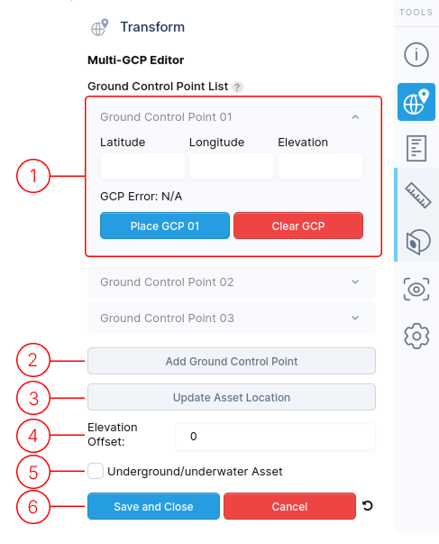
1.
By default, three ground control points (GCPs) are listed. Use the Add Ground Control Point button to add more points.
For each GCP:
- Click the ^ arrow to expand or collapse details.
- Enter the surveyed Latitude, Longitude, and Elevation coordinates (in meters).
- After entering all GCPs, click Update Asset Location button and the GCP Error value will be updated to display the point error.
- Use Place GCP to select a corresponding point on your 3D asset.
- The Clear GCP button removes both the entered data and selected position from the asset.
2.
The Add Ground Control Point button allows you to include additional points in the list.
3.
The Update Asset Location button calculates the optimal asset position and rotation based on the GCP data, then updates the asset's location on the globe map.
4.
If your surveyed elevation differs from the virtual map's terrain elevation, use the Elevation Offset field to adjust the asset's display level, ensuring it appears correctly on the terrain.
5.
If your asset is located underground or underwater, enable this option. The terrain map will become transparent when users approach the asset, revealing a yellow guide line that indicates its location below the surface.
6.
When finished editing, use these controls to exit the menu.
- Save and Close : Finalize your edits with this option.
- Cancel : Discard all changes made during this session.
- Reset icon : Revert all values back to defaults