Pre-Defined Geo-Reference
This editor assumes that your asset has already been geo-referenced by your processing software and does not need to be positioned on the map.
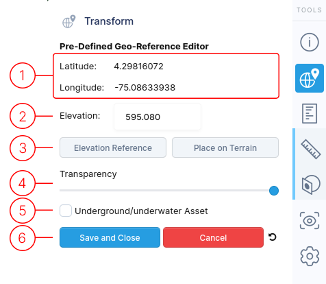
1.
Latitude and longitude values cannot be edited as they're determined by the software that created your model.
2.
You can edit the elevation value to position your asset correctly on the map's terrain.
3.
The Elevation Reference button lets you pick a specific spot on your model to be considered "ground level.".
Use Place on Terrain button to put your model directly on the terrain, especially if it's above or below the terrain.
- If you set an "Elevation Reference," that chosen spot will align with the terrain.
- If you don't set one, the middle of your model (its bounding box center) will be placed on the terrain
4.
Adjust the model's transparency to view the underlying map.
5.
Enable this feature for assets below ground level. The terrain becomes transparent upon close-up views, with a yellow guide line indicating the asset's exact location.
6.
When finished editing, use these controls to exit the menu.
- Save and Close : Finalize your edits with this option.
- Cancel : Discard all changes made during this session.
- Reset icon : Revert all values back to defaults